Educators rely on clear, durable world maps to spark curiosity and build geographic literacy. This guide highlights five top classroom-friendly maps designed for active learning, easy cleaning, and long-lasting use. From large laminated wall maps to kid-friendly posters, these options cover varied classroom needs, budgets, and spaces. Each selection emphasizes readability, up-to-date political boundaries, and write-on capability for interactive lessons.
Summary of Selected Products
| Product | Brand | Size | Key Benefit |
|---|---|---|---|
| Laminated World Map & US Map Poster Set | Palace Learning | 18″ x 29″ | Durable laminate; USA + World map combo |
| Maps International Giant World Map | Maps International | 46″ x 80″ | Largest single-sheet world map; write-on/wipe-clean |
| World Premier Wall Map Poster Mural | Swiftmaps | 24″ x 36″ | 3D terrain relief; laminated |
| 24×36 World and USA Classic Premier 3D | Swiftmaps | 24″ x 36″ | Two-map set; dry-erase compatible |
| Large World Map With Flags & Capitals | The World Game | 26″ x 38″ | Flags, capitals, 50 facts; classroom-ready |
Laminated World Map & US Map Poster Set

This two-map set combines a world map with a United States map on an 18″ x 29″ poster. The posters are laminated for durability, making them suitable for classrooms with daily use. The glue-free lamination helps resist moisture and fingerprints, while still allowing for dry-erase interaction with appropriate markers. The dual-poster format supports cross-country lessons and comparative geography activities.
Maps International Giant World Map

This oversized world map, measuring 46″ by 80″ and printed at a 1:20,000,000 scale, offers impressive visibility in larger classrooms or libraries. It features a vivid political color scheme, hill shading, and sea shading for depth. The map is heat-sealed between two film layers, making it durable and suitable for writing with whiteboard markers and wiping clean. It’s a standout option for immersive, large-group geography lessons.
Swiftmaps World Premier Wall Map Poster Mural

The World Premier wall map from Swiftmaps offers a portable 24″ x 36″ laminated poster with 3D shaded relief for land and oceans. Its foldable format makes transportation easier for school events or rotating displays. The laminated surface supports dry-erase markups, letting students annotate or highlight features during lessons while preserving the map’s clarity over time.
24×36 World and USA Classic Premier 3D

This two-map set pairs a world map with the United States map on laminated 100 lb paper, featuring 3D terrain relief. The dry-erase-capable surface supports repeated use in interactive lessons, quizzes, or student presentations. The larger format helps students compare continents, countries, and major geospatial features at a glance.
Swiftmaps 32″ x 50″ RMC Large World Wall Map

As a larger laminated option, this 32″ x 50″ world map delivers high visibility for classrooms with ample wall space. It includes up-to-date country boundaries and a durable two-sided lamination for dry-erase use. The map’s scale and detail support geography lessons, current events discussions, and student research projects.
2 Pack World Map Poster & USA Map Chart

This set includes two 18″ x 29″ laminated posters (World Map and USA Map). The two-poster pack is ideal for classrooms needing quick visual references across different grade levels. Laminated for durability, the posters support durable, long-term teaching aids and student engagement during geography activities.
Large World Map With Flags & Capitals
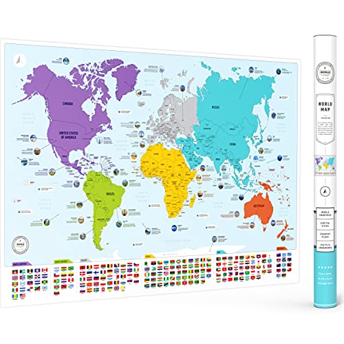
This large map highlights all countries with their flags and capitals, plus 50 interesting facts. It’s designed for both classroom and homeschool use, delivering a visually rich learning experience that supports memory retention and quick reference during geography lessons conducted for mixed-age groups.
Buying Guide: Key Purchase Considerations
- Size and wall space: Choose maps that fit your classroom dimensions. For large groups, oversized maps provide better visibility from the back of the room.
- Durability: Laminated surfaces and weather-resistant materials extend life in busy classrooms and reduce replacement costs.
- Write-on capability: If you expect frequent annotations or quizzes, opt for dry-erase friendly lamination or whiteboard-ready surfaces.
- Update frequency: Political boundaries and country information change. Consider maps labeled as updated in 2025 or with recent revisions for accuracy.
- Educational features: Look for added details such as capitals, flags, 3D relief, or fact blocks to enrich lessons and student engagement.
- Color and readability: High-contrast colors, clear borders, and legible fonts help students of all ages, including beginners, understand geography quickly.
- Accessibility and placement: Ensure the maps are hung at eye level for most students and accessible for interactive activities, with easy corner-access for tagging or pointing.
- Budget and bundles: Sets that include multiple maps (World + USA) or bundled packs can offer savings while covering diverse curriculum needs.
- Maintenance: Look for surfaces that are easy to wipe clean and resistant to marker stains or smudges to keep visuals crisp over time.
In evaluating options, educators should balance size, durability, and interactivity. Large, laminated maps are excellent for whole-class demonstrations, while smaller sets work well for stations or language-in-education activities. For classrooms focused on early learning, kid-friendly posters with bright colors and simple labeling can support foundational geography concepts. For libraries or media centers, oversized maps with durable coating and wipe-clean surfaces provide long-term value and flexible use across grade bands.